

A solution in the prevention and risk reduction of natural disaster
Monitoring heavy rain, early flood warning
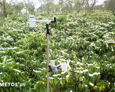
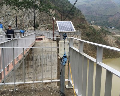
Build monitoring network with weather stations, precipitation stations in the chosen area to monitor real-time precipitation. Precipitation data is also used to give the forecast and adjust rounding error in the model. As a result, it provides weather forecast for subarea with high precision within six days and with hour resolution. From the data of real-time & forecast precipitation, Agrimedia builds hydrology models to describe exactly the basin which is studied, calculate flow rate and forecast flow. Based on calculated & forecasted flow data, Agrimedia makes flood map for downstream areas. Warning channel for emergency cases include:
– SMS message via mobile phone, is sent to a list or a broadcast region
– Website: update real-time flow diagram, flood map
– Email: send reporting or warning email
– Call center 9195 to support in any case.

Warning for flash flood and landslide
Spot with High potential of flashflood and landslide is set up a sensor network including Geophone sensors, string electrometer sensors, wire sensors, infrared camera monitoring flow. Areas under the influence in foot of a mountain or river side are equipped with warning lamp and alarm to immediately warn. Warning information is also sent via SMS, email, Website, mobile application. Whenever there are flashflood or landslide, sensors notice a small change in this environment condition and send signal which is processed by strong algorithm to center, at once emergency order is sent to warning lamp and alarm area.
Flashflood and landslide are closely related to precipitation. So that the combination of rainfall prediction system and flashflood & landslide warning system will be the overall solution of predicted and instant warning.
– Call center 24/7 not only support the information of weather and agriculture but also provides information of price, market, in-dept technical advice from leading experts of hydrology and agriculture in Vietnam.


140 comments on “A solution in the prevention and risk reduction of natural disaster”
https://undress.vip/
Looking forward to reading more. Great article post.Much thanks again.
india cricket news
I truly appreciate this blog.Much thanks again. Great.
emirates dubai visa
I cannot thank you enough for the post. Much obliged.
huddles
Enjoyed every bit of your blog.Thanks Again.
Fortune Tiger
I loved your blog article.Really thank you! Really Great.
efoil board
Thanks-a-mundo for the blog post.Much thanks again.
leather dog collar pattern
A round of applause for your blog post.Really looking forward to read more. Keep writing.
Resin Accessories
Looking forward to reading more. Great blog article.Thanks Again. Really Great.
End packaging cartoning machine
Great, thanks for sharing this blog article.Really thank you! Awesome.
Customized packaging machine
Really enjoyed this article post.Much thanks again. Great.
nsfw ai chat
Fantastic blog article.Really looking forward to read more. Want more.
ai girlfriend chat
This is one awesome article post.Much thanks again. Awesome.
nsfw ai chat
I cannot thank you enough for the blog.Much thanks again. Really Great.
新竹打炮
Awesome article post.Thanks Again. Cool.
桃園中壢定點約妹妹
Thanks for sharing, this is a fantastic blog.Really looking forward to read more. Will read on…
zoo mesh
Very neat blog post.
NSFW AI
Thanks again for the blog post. Cool.
Synthetic wigs
I really liked your article.Thanks Again. Awesome.
High ponytail synthetic wig
Appreciate you sharing, great blog post.Much thanks again. Keep writing.
Vastu products
Very good post. Really Cool.
Utendørs rørinspeksjon
This is one awesome blog article.Really looking forward to read more. Awesome.
garam masala
Thanks-a-mundo for the post.Much thanks again. Will read on…
stock market classes in pune
Fantastic article post.Thanks Again. Much obliged.
steel flange manufacturer
Thank you ever so for you article post. Great.
canada work permit jobs
Great, thanks for sharing this blog.Thanks Again. Will read on…
himachal pradesh news today
A big thank you for your blog post.Much thanks again. Will read on…
chai ai
Major thankies for the article.Really thank you! Great.
chai ai
Really informative blog post.Much thanks again. Will read on…
electric toothbrush charger
Great blog post.Much thanks again. Much obliged.
eggc
qiyezp.com
그 위에는 “뇌 질환의 원리와 치료”라는 의학 논문이 있었습니다.
qiyezp.com
sandyterrace.com
홍지황제가 화를 내며 말했다.
instagram pro
A big thank you for your blog post.Really thank you! Want more.
talkie ai
I cannot thank you enough for the blog.Really thank you! Keep writing.
kit diamond painting
Appreciate you sharing, great blog article.
nsfw character ai
Im grateful for the blog. Keep writing.
devin ai
This is one awesome blog article. Much obliged.
nsfw ai chat
I really liked your post.Much thanks again. Cool.
High Waisted Menstrual Underwear
Muchos Gracias for your article.Really looking forward to read more. Really Great.
40 days crash course for neet biology
Thanks for the article.Much thanks again. Will read on…
wall art home decor
I really like and appreciate your blog.Thanks Again. Fantastic.
Residential duct system replacement in Fort Pierce
I really like and appreciate your blog. Much obliged.
Dairy products in raj nagar ghaziabad
Thank you ever so for you article.Thanks Again. Cool.
hr software suppliers
Say, you got a nice blog article.Thanks Again. Awesome.
acrylic led name plate
Great article post. Really Great.
pearl academy entrance exam 2021
Thank you for your post.Thanks Again. Great.
에그뱃
sandyterrace.com
이때는 더욱 조심하고 입을 다무는 것이 좋다.
best thailand tour packages from chennai
This is one awesome article post.Much thanks again. Will read on…
arena plus promo code
I really enjoy the article. Really Cool.
qiyezp.com
qiyezp.com
Hongzhi 황제에게 큰 상자가 배달되었습니다.
Qingdao Baixi Industry
I really liked your blog article. Much obliged.
留学生高分论文代写
Thanks so much for the blog article.Thanks Again. Cool.
GB WhatsApp
This is one awesome blog. Great.
Fouad WhatsApp
Thanks so much for the blog.Much thanks again. Cool.
Descargar WhatsApp Plus
Thanks again for the article post.Much thanks again. Really Cool.
FM WhatsApp download
Thank you for your post.Really looking forward to read more. Really Great.
NSFW Generator AI
Thank you ever so for you post.Really looking forward to read more. Want more.
Ai Anime generator
Very informative post.Much thanks again. Keep writing.
today isl live score
Thanks so much for the article. Fantastic.
토토사이트
Appreciating the persistence you put into your blog and in depth information you offer.
It’s nice to come across a blog every once in a while that
isn’t the same out of date rehashed material. Wonderful read!
I’ve bookmarked your site and I’m adding your RSS feeds to my
Google account.
Feel free to visit my blog :: 토토사이트
live cricket score women wpl
I really liked your post.Really looking forward to read more. Awesome.
메이저사이트
I’m not sure the place you’re getting your information, but great topic.
I must spend a while studying more or working
out more. Thank you for wonderful info I was on the lookout
for this information for my mission.
Feel free to surf to my web blog: 메이저사이트
today ipl match live score
I appreciate you sharing this post. Great.
satta matta matka madhur guessing
Really enjoyed this article.Really looking forward to read more.
satta matka chart night
Very informative blog.Really looking forward to read more. Great.
bangalore to kedarnath bus booking
Say, you got a nice blog post. Really Great.
먹튀
My spouse and I stumbled over here different page and thought I may as well check things out.
I like what I see so now i am following you. Look forward to looking over your web page again.
My web-site :: 먹튀
fx마진거래
I am in fact delighted to glance at this web site posts which carries lots of valuable facts, thanks for
providing such information.
Feel free to visit my website; fx마진거래
online bus ticket booking app
Fantastic post. Keep writing.
bharat benz coach bus in greater noida
Im grateful for the article.Thanks Again. Keep writing.
온라인슬롯
After looking into a number of the blog articles on your web site, I seriously like
your way of writing a blog. I saved it to my bookmark site list
and will be checking back soon. Please check out my website as well and let me know your opinion.
Review my web site – 온라인슬롯
silver hoop earrings for women
Thanks again for the blog post.Thanks Again. Much obliged.
먹튀검증
Nice post. I was checking constantly this blog and I am inspired!
Very helpful information particularly the last part :
) I handle such information much. I used to be looking for this certain information for a very lengthy time.
Thank you and good luck.
Visit my web blog :: 먹튀검증
website maintenance service
Thanks for sharing, this is a fantastic blog article.Really looking forward to read more.
injection machine supplier
Very good article.Thanks Again. Really Great.
現金網香港
A round of applause for your blog article.Really thank you! Great.
바카라사이트
Highly descriptive post, I loved that bit. Will there be a part 2?
My web blog 바카라사이트
Injection Machine
Major thanks for the post.Really thank you! Much obliged.
custom clothing
I value the article post.Much thanks again. Awesome.
one on one topics with manager
A big thank you for your article post.Thanks Again. Cool.
frequent team huddles can contribute to:
I cannot thank you enough for the post.Thanks Again. Really Cool.
ai hentai chat
Looking forward to reading more. Great article post.Much thanks again. Cool.
nsfw ai chat
Thanks-a-mundo for the blog.Really looking forward to read more. Really Great.
hommar
Major thankies for the blog article.Much thanks again. Want more.
ai sex chat
Thanks again for the blog article. Will read on…
character ai no filter
Hey, thanks for the blog.Really thank you! Great.
keeper ai test
Thanks for sharing, this is a fantastic article.Much thanks again. Much obliged.
ai hentai character
Muchos Gracias for your blog.Thanks Again. Cool.
spicy chat
I really enjoy the blog post.Really looking forward to read more. Awesome.
character ai
Appreciate you sharing, great post.Thanks Again. Really Cool.
ai anime
Say, you got a nice article.Really looking forward to read more. Great.
Ai girlfriend
Thank you ever so for you article post. Really Great.
c.ai
Awesome post. Keep writing.
smash or pass
Really appreciate you sharing this article.Thanks Again. Will read on…
sklep online
Wow, fantastic blog layout! How long have you ever been running a blog for?
you make blogging look easy. The full look of your site is fantastic, let alone
the content material! You can see similar here e-commerce
pharmacy com canada
online pharmacy no presc uk
affordable custom shirts
Major thankies for the blog.Really thank you! Keep writing.
binance
Can you be more specific about the content of your article? After reading it, I still have some doubts. Hope you can help me.
human hair wigs african american
Really appreciate you sharing this article.Really thank you! Will read on…
cosplay wigs
I am so grateful for your blog.Really thank you! Will read on…
chain link fence kits
Thanks again for the blog post.Really looking forward to read more. Really Cool.
slsmachinery
Awesome post.Really looking forward to read more.
https://www.slsmachinery.com
Really appreciate you sharing this article post.Really looking forward to read more. Will read on…
优美之家
I truly appreciate this blog post. Cool.
优美之家
Thanks again for the article post. Will read on…
Chloe Love
Hot Tattooed free live sex cams Goddess Ready for Fun and Money
nsfw character ai
Great, thanks for sharing this article post.Much thanks again. Much obliged.
Spotify MOD
Thanks for sharing, this is a fantastic article post.Much thanks again. Much obliged.
led light softball display case
This is one awesome blog article.Really thank you! Will read on…
benefits of light therapy for sleep
wow, awesome article.Much thanks again. Much obliged.
Dolce & Gabbana t shirt
Awesome article.Much thanks again.
pia proxy
Great article. Awesome.
飞机语言包
Say, you got a nice blog post.Really thank you! Will read on…
电报汉化
I loved your blog article.Really thank you! Will read on…
screw machining services
Very neat blog article. Really Great.
Jogo do tigre
I am so grateful for your post.Really looking forward to read more. Awesome.
去马尔代夫旅游要多少钱
I truly appreciate this blog.Thanks Again. Want more.
SLS Machinery
Wow, great post. Really Great.
SLS Machinery Co.,Ltd
Im obliged for the blog post.Much thanks again. Keep writing.
Hospital Bed
Great blog article.Really thank you! Awesome.
京牌靓号
Im grateful for the article.Thanks Again. Really Great.
anime ai chat
I loved your blog post.Really thank you! Fantastic.
dirty talk ai
Im thankful for the blog article.Thanks Again. Great.
ai waifu chat
I am so grateful for your blog.Really thank you! Cool.
AI sexting
Really informative blog post.Really thank you! Really Great.
character ai no filter
Enjoyed every bit of your blog. Will read on…
character ai hentai
Thanks for sharing, this is a fantastic post.Much thanks again. Want more.
gay ai chat
I am so grateful for your blog article.Much thanks again. Much obliged.
jerk off chat
I am so grateful for your blog post.Much thanks again.
cuckold ai
Looking forward to reading more. Great blog article.Much thanks again.
smash or pass
I cannot thank you enough for the post. Really Cool.
free AI sexting
Major thankies for the post. Cool.
ai girfriend
wow, awesome blog article. Great.
talkie ai
Im thankful for the post. Cool.
janitor ai chat
Wow, great article post.Really thank you! Will read on…
trusted online pharmacy
no prescription needed pharmacy
Face swap ai
Looking forward to reading more. Great blog.Much thanks again. Awesome.
perya game
I loved your blog article.Really looking forward to read more. Fantastic.
LED Strip Light Wholesale
I really liked your article.Really looking forward to read more. Much obliged.
buy vape bulk
Fantastic blog. Really Great.
sikimin onunde egilceksin
I appreciate you sharing this blog post. Thanks Again. Cool.